File:BalticStatesBorders.svg.png
Jump to navigation
Jump to search


Size of this preview: 729 × 600 pixels. Other resolutions: 292 × 240 pixels | 2,490 × 2,048 pixels.
Original file (2,490 × 2,048 pixels, file size: 446 KB, MIME type: image/png)
Summary
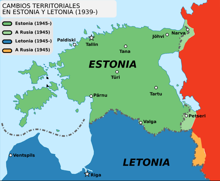
Territories annexed by the USSR from Estonia and Latvia by the Soviet aggression in 1940 and remained under the Russian control at least until year 2021. [1]
Original filename: https://upload.wikimedia.org/wikipedia/commons/thumb/0/0a/BalticStatesBorders.svg/2490px-BalticStatesBorders.svg.png
References
- ↑ https://commons.wikimedia.org/wiki/File:Baltic_states_borders.jpg border changes of Estonia and Latvia between 1939 and 2001 Border changes drawn based on Goode's World Atlas, editions 1934 & 2001, RAND&McNALLY, CHICAGO
File history
Click on a date/time to view the file as it appeared at that time.
| Date/Time | Thumbnail | Dimensions | User | Comment | |
|---|---|---|---|---|---|
| current | 07:09, 4 November 2021 |  | 2,490 × 2,048 (446 KB) | T (talk | contribs) | == Summary == Territories annexed by the USSR from Estonia and Latvia by the Soviet aggression in 1940 and remained under the Russian control at least until year 2021. <ref> https://commons.wikimedia.org/wiki/File:Baltic_states_borders.jpg... |
You cannot overwrite this file.
File usage
There are no pages that use this file.