File:L57.9792z33.3020map9.jpg

Original file (1,440 × 990 pixels, file size: 336 KB, MIME type: image/jpeg)
Summary
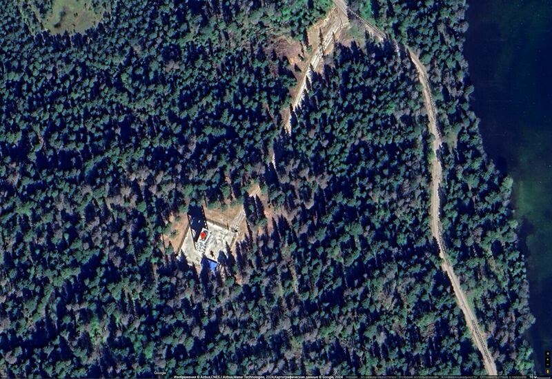
Satellite view from South at L57.9792z33.3020, element of the ValdaiCluster.
Image by Google maps [1]
The object at the top of the tower is identified as Pantsir-S1 missile system (SAM)
References
- ↑ https://www.google.co.jp/maps/place/57°58'45.1%22N+33°18'07.2%22E/@57.9796081,33.3014045,322m/data=!3m1!1e3!4m4!3m3!8m2!3d57.9792!4d33.302?hl=ru&entry=ttu // 57°58'45.1"N 33°18'07.2"E 57.979200, 33.302000 Валдай, Новгородская обл., Россия
Keywords
«Annexation of Crimea», «Budapest memorandum», «Demilitarization», «Denazification», «Designate Russia as state sponsor of terrorism», «Designate Russia as terrorist state», «Fascism», «I bombed Dresden», «L57.9792z33.3020», «Moscovia», «New World Order», «[[]]», «Pahanat», «Putin world war», «Radio Svoboda», «Russian invasion into Ukraine», «Russki mir», «SA-22 Greyhound», «Transfer of hostilities to aggressor territory», «Valdai Putin Residence», «ValdaiCluster», «ValdaiPutinResidence8.png»,
«А нас то за что», «Аннексия Крыма», «Будапештский меморандум», «Валдайский Дворец Путина», «Валдайский Кластер», «Валдайская Резиденция Путина», «Денег нет», «Московия», «Новый Мировой Порядок», «Ново-Огарево», «Панцирь-С1», «Перенос боевых действий на территорию страны агрессора», «Путинская мировая война», «Радио Свобода», «Русский мир», «Спецоперция», «[[]]», «Фашизм»,
File history
Click on a date/time to view the file as it appeared at that time.
| Date/Time | Thumbnail | Dimensions | User | Comment | |
|---|---|---|---|---|---|
| current | 19:34, 28 July 2024 |  | 1,440 × 990 (336 KB) | T (talk | contribs) | {{oq|L57.9792z33.3020map9.jpg|}} Satellite view from South at L57.9792z33.3020, element of the ValdaiCluster. Image by Google maps <ref> https://www.google.co.jp/maps/place/57°58'45.1%22N+33°18'07.2%22E/@57.9796081,33.3014045,322m/data=!3m1... |
You cannot overwrite this file.
File usage
The following page uses this file:
- Air defense
- Annexation of Crimea
- Budapest memorandum
- Demilitarization
- Denazification
- Designate Russia as state sponsor of terrorism
- Designate Russia as terrorist state
- Fascism
- L57.9792z33.3020
- Moscovia
- New World Order
- Pahanat
- Pantsir-S1
- Putin world war
- Radio Svoboda
- Russian invasion into Ukraine
- Russki mir
- SA-22 Greyhound
- Target
- Transfer of hostilities to aggressor territory
- Valdai Putin Residence
- ValdaiCluster
- ValdaiPutinResidence8