File:Znamenka19.jpg
Jump to navigation
Jump to search


Size of this preview: 524 × 600 pixels. Other resolutions: 210 × 240 pixels | 796 × 911 pixels.
Original file (796 × 911 pixels, file size: 134 KB, MIME type: image/jpeg)
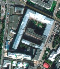
Aerial view of the Russian ministry of Defence, Znamenka 18.
Coordinates: 55.7498, 37.6026
(55°44'59"N 37°36'09"E)
Source: https://www.google.co.jp/maps/place/55°44'59.3%22N+37°36'09.4%22E
File history
Click on a date/time to view the file as it appeared at that time.
| Date/Time | Thumbnail | Dimensions | User | Comment | |
|---|---|---|---|---|---|
| current | 06:14, 1 December 2018 | | 796 × 911 (134 KB) | Maintenance script (talk | contribs) | Importing image file |
You cannot overwrite this file.
File usage
There are no pages that use this file.