Difference between revisions of "File:Demis-kurils-russian names.png"
Jump to navigation
Jump to search
(Importing image file) |
|||
| Line 1: | Line 1: | ||
| + | Kuril Islands overview map with current Russian names (English transliteration). Borders of Shimoda Treaty (1855) and Treaty of St. Petersburg (1875) shown in red. Currently all islands northeast of Hokkaido are administered by Russia. |
||
| − | Importing image file |
||
| + | |||
| + | Note: Ushishir actually consists of 2 islands: Ryponkicha (northeast) and Yankicha (southwest). |
||
| + | |||
| + | See also The Habomai Islands |
||
| + | |||
| + | Source: |
||
| + | https://commons.wikimedia.org/wiki/File:Demis-kurils-russian_names.png |
||
| + | |||
| + | ==References== |
||
| + | <references/> |
||
| + | |||
| + | [[Category:Aggression]] |
||
| + | [[Category:Kuril islands]] |
||
| + | [[Category:Map]] |
||
Latest revision as of 08:34, 1 December 2018
Kuril Islands overview map with current Russian names (English transliteration). Borders of Shimoda Treaty (1855) and Treaty of St. Petersburg (1875) shown in red. Currently all islands northeast of Hokkaido are administered by Russia.
Note: Ushishir actually consists of 2 islands: Ryponkicha (northeast) and Yankicha (southwest).
See also The Habomai Islands
Source: https://commons.wikimedia.org/wiki/File:Demis-kurils-russian_names.png
References
File history
Click on a date/time to view the file as it appeared at that time.
| Date/Time | Thumbnail | Dimensions | User | Comment | |
|---|---|---|---|---|---|
| current | 06:11, 1 December 2018 | 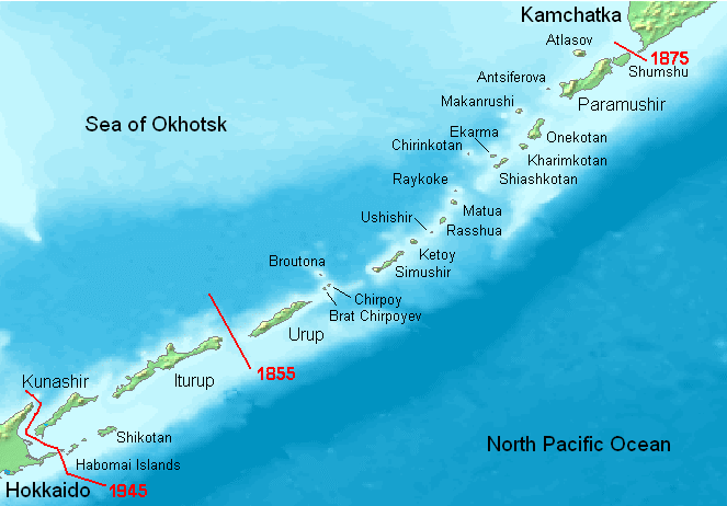 | 663 × 462 (70 KB) | Maintenance script (talk | contribs) | Importing image file |
You cannot overwrite this file.
File usage
The following 4 pages use this file: