File:2016.04.16.EqrthquakeMap.jpg
Revision as of 08:27, 1 December 2018 by Maintenance script (talk | contribs)
Size of this preview: 643 × 600 pixels. Other resolutions: 257 × 240 pixels | 962 × 897 pixels.
Original file (962 × 897 pixels, file size: 112 KB, MIME type: image/jpeg)
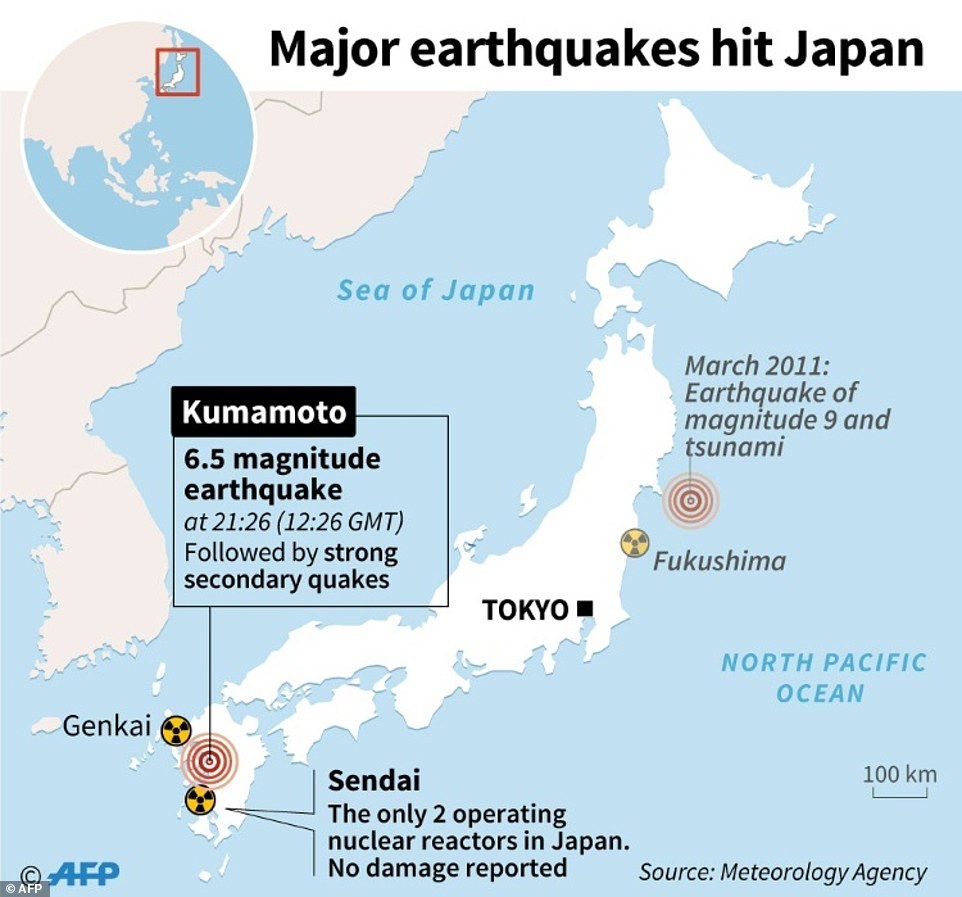
Map of Japan showing the 2016.04.16.Eqrthquake and the 2011.03.12 earthquake (that followed by the Fukushima disaster) [1]
Original filename: http://i.dailymail.co.uk/i/pix/2016/04/15/08/3x3xJf8qEp7439795a5865916b8c-3541249-Powerful_earthquakes_hit_Japan_John_SAEKI_Adrian_LEUNG_Alain_BOM-a-37_1460705642142.jpg
References
- ↑ http://www.dailymail.co.uk/news/article-3542347/Japan-rocked-second-powerful-earthquake-7-4-scale-just-24-hours-deadly-quake-hit-region.html JAMES DUNN and ALEX MATTHEWS and JULIAN ROBINSON FOR MAILONLINE and SINEAD MACLAUGHLIN FOR DAILY MAIL AUSTRALIA. Devastating landslide rips a Japanese mountain apart: Death toll rises to 36 after second earthquake destroys roads, bridges and homes. PUBLISHED: 18:01 GMT, 15 April 2016 | UPDATED: 13:06 GMT, 16 April 2016.
File history
Click on a date/time to view the file as it appeared at that time.
| Date/Time | Thumbnail | Dimensions | User | Comment | |
|---|---|---|---|---|---|
| current | 06:09, 1 December 2018 | | 962 × 897 (112 KB) | Maintenance script (talk | contribs) | Importing image file |
You cannot overwrite this file.
File usage
There are no pages that use this file.