File:KirpichnayaBoderPatrolStorageMap.jpg
Jump to navigation
Jump to search


Size of this preview: 800 × 540 pixels. Other resolutions: 320 × 216 pixels | 1,666 × 1,124 pixels.
Original file (1,666 × 1,124 pixels, file size: 535 KB, MIME type: image/jpeg)
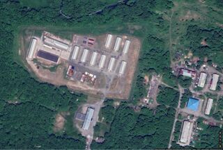
Map [1] of the storage site of the Russian border patrol at river Kirpichnaya, Kamchatka.
Coordinates:
53.03053, 158.72696
This organization is suspected to contribute in the contamination, caused the 2020.10.01.Kamchatka disaster
References
File history
Click on a date/time to view the file as it appeared at that time.
| Date/Time | Thumbnail | Dimensions | User | Comment | |
|---|---|---|---|---|---|
| current | 20:11, 13 October 2020 | | 1,666 × 1,124 (535 KB) | T (talk | contribs) |
You cannot overwrite this file.
File usage
There are no pages that use this file.